
Home > PhV > Online Exhibitions > Timothy O'Sullivan: Explorations and Surveys West of the 100th Meridian (1871-1874)
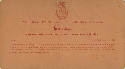
Back of stereocard
[Wheeler Survey, Explorations and Surveys West of the 100th Meridian]
1871-1874 (survey)
Stereocard
Etherton Gallery
LL/24708
1 of 101
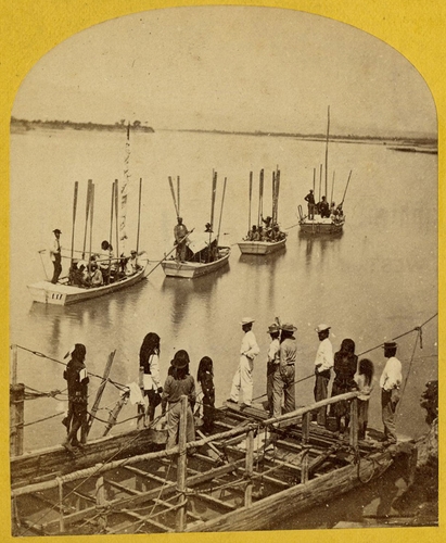
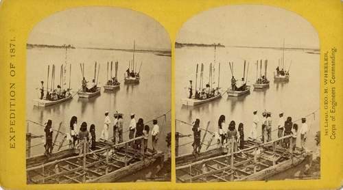
The start from Camp Mojave, Arizona, September 13, 1871.
[Wheeler Survey, Explorations and Surveys West of the 100th Meridian]
1871-1874 (survey), 1871, 13 September (taken)
Stereocard, detail
Etherton Gallery
LL/24709 [Further details available]
2 of 101
The start from Camp Mojave, Arizona, September 13, 1871.
[Wheeler Survey, Explorations and Surveys West of the 100th Meridian]
1871-1874 (survey), 1871, 13 September (taken)
Stereocard
Etherton Gallery
LL/24710 [Further details available]
3 of 101

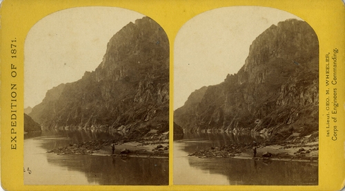
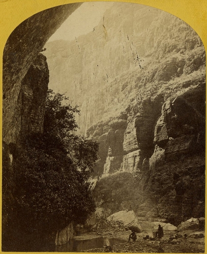
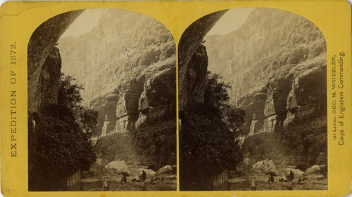
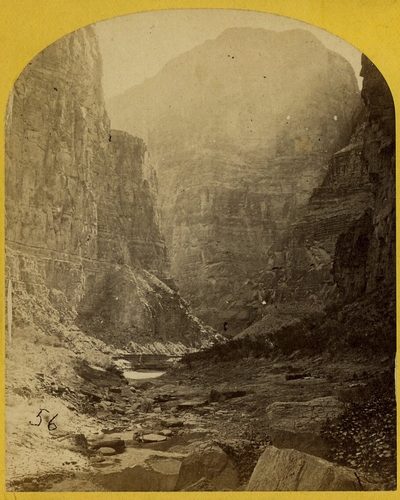
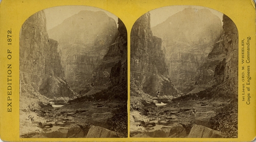
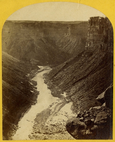
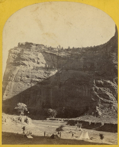
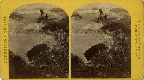
2. View across Black Canon. the grand walls in perspective.
[Wheeler Survey, Explorations and Surveys West of the 100th Meridian]
1871-1874 (survey), 1871 (expedition)
Stereocard, detail
Etherton Gallery
LL/24711
4 of 101
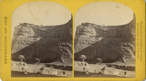
2. View across Black Canon. the grand walls in perspective.
[Wheeler Survey, Explorations and Surveys West of the 100th Meridian]
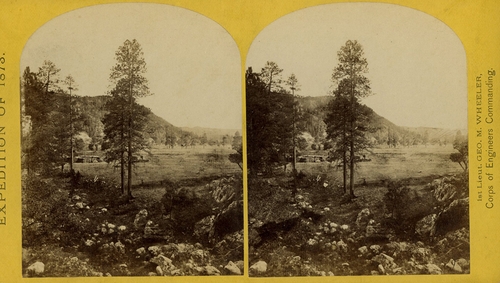
1871-1874 (survey), 1871 (expedition)
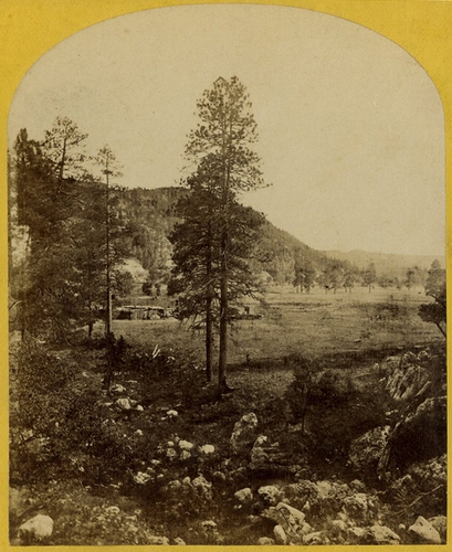
Stereocard
Etherton Gallery
LL/24712
5 of 101
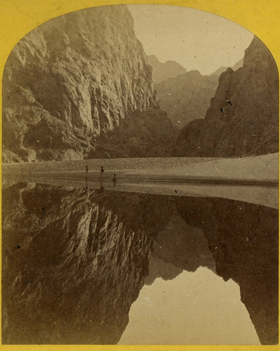
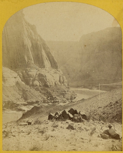
3. View down Black Canon, from Mirror Bar. the walls repeated by reflection.
[Wheeler Survey, Explorations and Surveys West of the 100th Meridian]
1871-1874 (survey), 1871 (expedition)
Stereocard, detail
Etherton Gallery
LL/24713
6 of 101
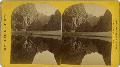
3. View down Black Canon, from Mirror Bar. the walls repeated by reflection.
[Wheeler Survey, Explorations and Surveys West of the 100th Meridian]
1871-1874 (survey), 1871 (expedition)
Stereocard
Etherton Gallery
LL/24714
7 of 101
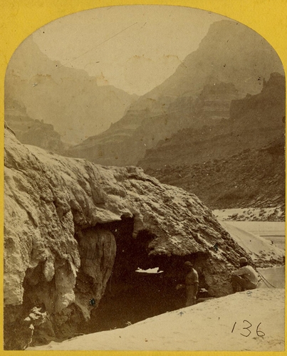
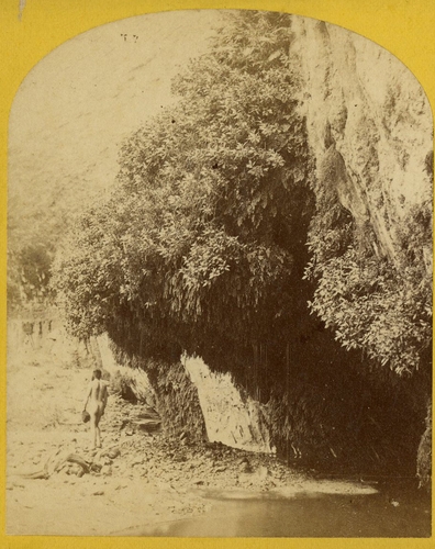
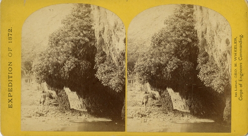
4. Grotto Spring, Grand Canon, Colorado River.
[Wheeler Survey, Explorations and Surveys West of the 100th Meridian]
1871-1874 (survey), 1871 (expedition)
Stereocard, detail
Etherton Gallery
LL/24715
8 of 101
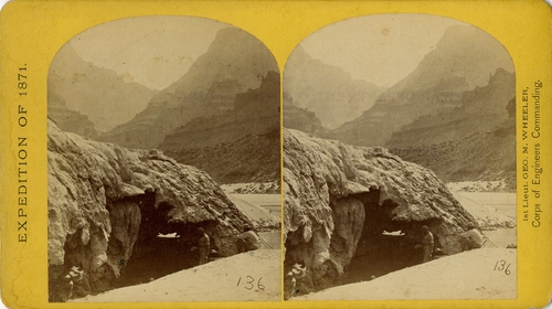
4. Grotto Spring, Grand Canon, Colorado River.
[Wheeler Survey, Explorations and Surveys West of the 100th Meridian]
1871-1874 (survey), 1871 (expedition)
Stereocard
Etherton Gallery
LL/24716
9 of 101
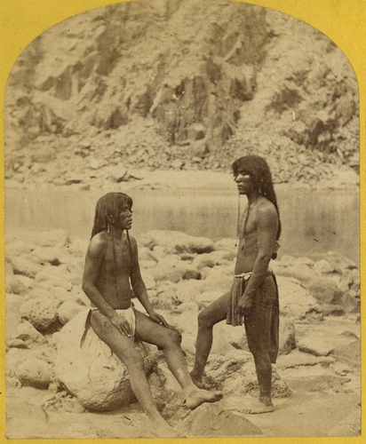
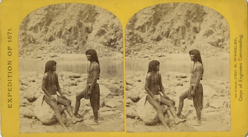
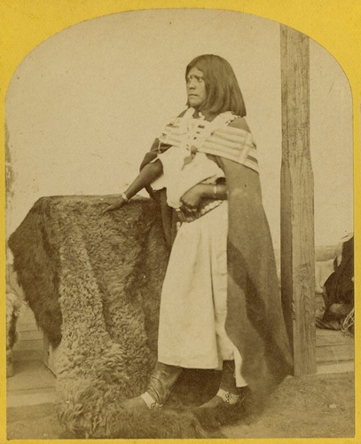
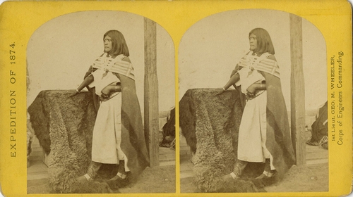
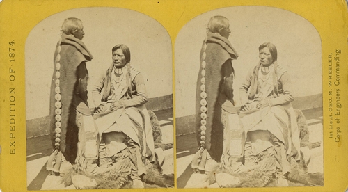
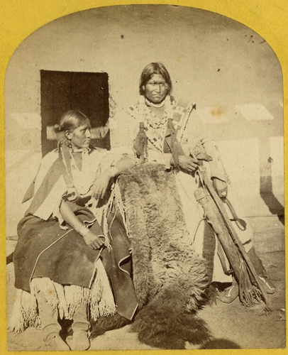
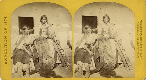
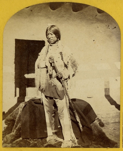
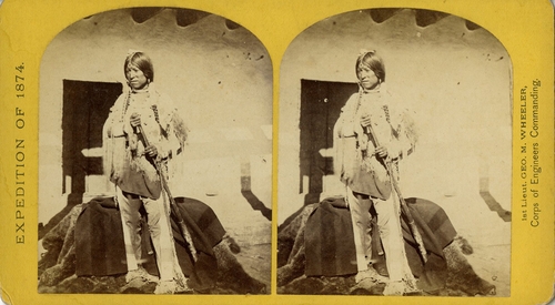
5. Types of Mojave Indians. this tribe inhabits the region of the lower Colorado, or western Arizona. Physically they are the finest specimens in all the west, many of the males attaining to the height of 8 feet.
[Wheeler Survey, Explorations and Surveys West of the 100th Meridian]
1871-1874 (survey), 1871 (expedition)
Stereocard, detail
Etherton Gallery
LL/24717
10 of 101
5. Types of Mojave Indians. this tribe inhabits the region of the lower Colorado, or western Arizona. Physically they are the finest specimens in all the west, many of the males attaining to the height of 8 feet.
[Wheeler Survey, Explorations and Surveys West of the 100th Meridian]
1871-1874 (survey), 1871 (expedition)
Stereocard
Etherton Gallery
LL/24718
11 of 101
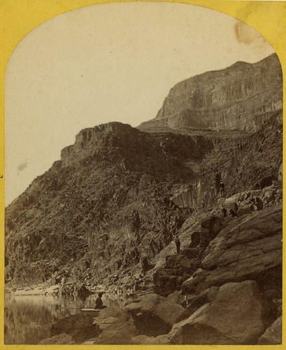
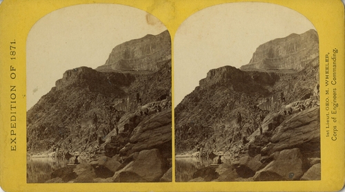
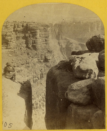
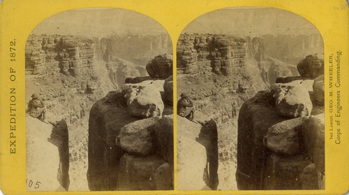
6. View of the Grand Canon walls, near mouth of Diamond River. From waterline to first shelf 1,500 feet; from shelf to top of table 3,500 feet. Distance from point of view to top of walls 3 miles.
[Wheeler Survey, Explorations and Surveys West of the 100th Meridian]
1871-1874 (survey), 1871 (expedition)
Stereocard, detail
Etherton Gallery
LL/24719
12 of 101
6. View of the Grand Canon walls, near mouth of Diamond River. From waterline to first shelf 1,500 feet; from shelf to top of table 3,500 feet. Distance from point of view to top of walls 3 miles.
[Wheeler Survey, Explorations and Surveys West of the 100th Meridian]
1871-1874 (survey), 1871 (expedition)
Stereocard
Etherton Gallery
LL/24720
13 of 101
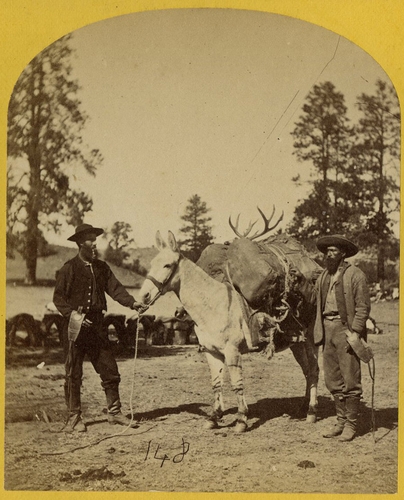
7. Mountain transportation. Pack mule, Pack and Packers.
[Wheeler Survey, Explorations and Surveys West of the 100th Meridian]
1871-1874 (survey), 1871 (expedition)
Stereocard, detail
Etherton Gallery
LL/24721
14 of 101

7. Mountain transportation. Pack mule, Pack and Packers.
[Wheeler Survey, Explorations and Surveys West of the 100th Meridian]
1871-1874 (survey), 1871 (expedition)
Stereocard
Etherton Gallery
LL/24722
15 of 101
8. the Canon of Kanab Creek, near its junction with the Grand Canon of the Colorado. In the foreground is a dripping spring affording a shower bath. Temperature, 69O. Fahr.
[Wheeler Survey, Explorations and Surveys West of the 100th Meridian]
1871-1874 (survey), 1872 (expedition)
Stereocard, detail
Etherton Gallery
LL/24723
16 of 101
8. the Canon of Kanab Creek, near its junction with the Grand Canon of the Colorado. In the foreground is a dripping spring affording a shower bath. Temperature, 69O. Fahr.
[Wheeler Survey, Explorations and Surveys West of the 100th Meridian]
1871-1874 (survey), 1872 (expedition)
Stereocard
Etherton Gallery
LL/24724
17 of 101
9. "the Bath," a dripping spring in Kanab Canon. Temperature, 69O. Fahr.
[Wheeler Survey, Explorations and Surveys West of the 100th Meridian]
1871-1874 (survey), 1872 (expedition)
Stereocard, detail
Etherton Gallery
LL/24725
18 of 101
9. "the Bath," a dripping spring in Kanab Canon. Temperature, 69O. Fahr.
[Wheeler Survey, Explorations and Surveys West of the 100th Meridian]
1871-1874 (survey), 1872 (expedition)
Stereocard
Etherton Gallery
LL/24726
19 of 101
10. the mouth of Kanab Creek.
[Wheeler Survey, Explorations and Surveys West of the 100th Meridian]
1871-1874 (survey), 1872 (expedition)
Stereocard, detail
Etherton Gallery
LL/24727
20 of 101
10. the mouth of Kanab Creek.
[Wheeler Survey, Explorations and Surveys West of the 100th Meridian]
1871-1874 (survey), 1872 (expedition)
Stereocard
Etherton Gallery
LL/24728
21 of 101
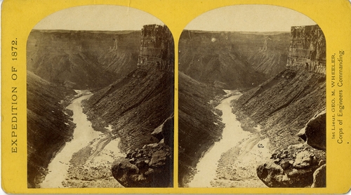
11. Mouth of the Paria, Colorado River, walls 2,100 feet in height.
[Wheeler Survey, Explorations and Surveys West of the 100th Meridian]
1871-1874 (survey), 1872 (expedition)
Stereocard, detail
Etherton Gallery
LL/24729
22 of 101
11. Mouth of the Paria, Colorado River, walls 2,100 feet in height.
[Wheeler Survey, Explorations and Surveys West of the 100th Meridian]
1871-1874 (survey), 1872 (expedition)
Stereocard
Etherton Gallery
LL/24730
23 of 101
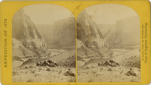
12. View in the Grand Canon of the Colorado River.
[Wheeler Survey, Explorations and Surveys West of the 100th Meridian]
1871-1874 (survey), 1872 (expedition)
Stereocard, detail
Etherton Gallery
LL/24731
24 of 101
12. View in the Grand Canon of the Colorado River.
[Wheeler Survey, Explorations and Surveys West of the 100th Meridian]
1871-1874 (survey), 1872 (expedition)
Stereocard
Etherton Gallery
LL/24732
25 of 101
13. Marble Canon, one of the gorges of the Colorado, here 1,200 feet deep. The steep cliff is gray limestone and the slope below a brilliant red sandstone.
[Wheeler Survey, Explorations and Surveys West of the 100th Meridian]
1871-1874 (survey), 1872 (expedition)
Stereocard, detail
Etherton Gallery
LL/24733
26 of 101
13. Marble Canon, one of the gorges of the Colorado, here 1,200 feet deep. The steep cliff is gray limestone and the slope below a brilliant red sandstone.
[Wheeler Survey, Explorations and Surveys West of the 100th Meridian]
1871-1874 (survey), 1872 (expedition)
Stereocard
Etherton Gallery
LL/24734
27 of 101
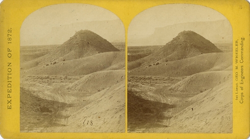
14. the northern wall of the Grand Canon of the Colorado, near the foot of To-ro-weap valley. The rounded rocks of the foreground are sand-stone.
[Wheeler Survey, Explorations and Surveys West of the 100th Meridian]
1871-1874 (survey), 1872 (expedition)
Stereocard, detail
Etherton Gallery
LL/24735
28 of 101
14. the northern wall of the Grand Canon of the Colorado, near the foot of To-ro-weap valley. The rounded rocks of the foreground are sand-stone.
[Wheeler Survey, Explorations and Surveys West of the 100th Meridian]
1871-1874 (survey), 1872 (expedition)
Stereocard
Etherton Gallery
LL/24736
29 of 101
15. the "Vermillion Cliff," a typical plateau edge, as seen from Jacobs Pool, Arizona. From its top, a plateau stretches to the right, and from its base another to the left. Their difference of level is 1,500 feet, and the step is too steep for scaling.
[Wheeler Survey, Explorations and Surveys West of the 100th Meridian]
1871-1874 (survey), 1872 (expedition)
Stereocard, detail
Etherton Gallery
LL/24737
30 of 101
15. the "Vermillion Cliff," a typical plateau edge, as seen from Jacobs Pool, Arizona. From its top, a plateau stretches to the right, and from its base another to the left. Their difference of level is 1,500 feet, and the step is too steep for scaling.
[Wheeler Survey, Explorations and Surveys West of the 100th Meridian]
1871-1874 (survey), 1872 (expedition)
Stereocard
Etherton Gallery
LL/24738
31 of 101

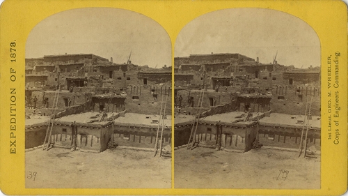
16. Indian Pueblo of Zuni, New Mexico; view from the interior.
[Wheeler Survey, Explorations and Surveys West of the 100th Meridian]
1871-1874 (survey), 1873 (expedition)
Stereocard, detail
Etherton Gallery
LL/24739
32 of 101
16. Indian Pueblo of Zuni, New Mexico; view from the interior.
[Wheeler Survey, Explorations and Surveys West of the 100th Meridian]
1871-1874 (survey), 1873 (expedition)
Stereocard
Etherton Gallery
LL/24740
33 of 101
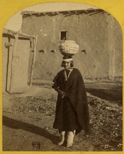
17. Zuni Indian girl, with water olla.
[Wheeler Survey, Explorations and Surveys West of the 100th Meridian]
1871-1874 (survey), 1873 (expedition)
Stereocard, detail
Etherton Gallery
LL/24741
34 of 101
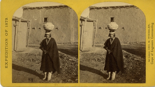
17. Zuni Indian girl, with water olla.
[Wheeler Survey, Explorations and Surveys West of the 100th Meridian]
1871-1874 (survey), 1873 (expedition)
Stereocard
Etherton Gallery
LL/24742
35 of 101
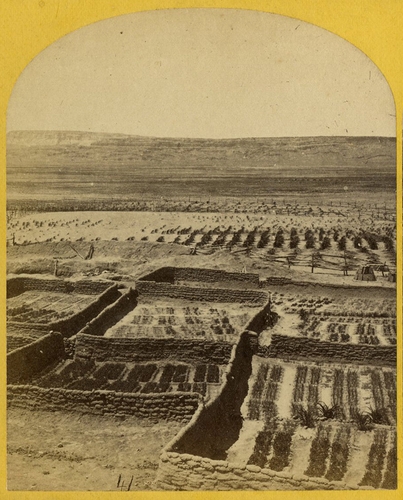
18. Gardens surrounding the Indian Pueblo of Zuni, in which are raised a variety of vegetables, such as pepper, onions, garlic &c.
[Wheeler Survey, Explorations and Surveys West of the 100th Meridian]
1871-1874 (survey), 1873 (expedition)
Stereocard, detail
Etherton Gallery
LL/24743
36 of 101
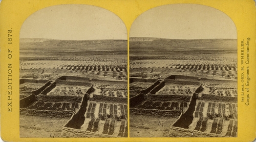
18. Gardens surrounding the Indian Pueblo of Zuni, in which are raised a variety of vegetables, such as pepper, onions, garlic &c.
[Wheeler Survey, Explorations and Surveys West of the 100th Meridian]
1871-1874 (survey), 1873 (expedition)
Stereocard
Etherton Gallery
LL/24744
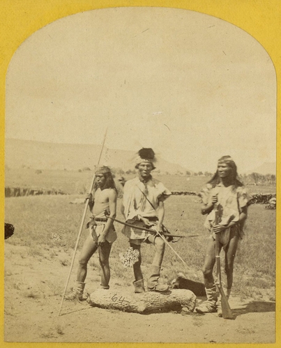
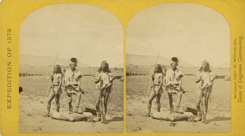
37 of 101
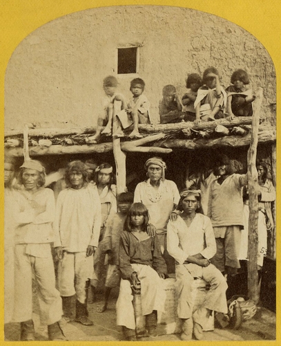
19. Group of Zuni Indian, "Braves," at their Pueblo, N.M.
[Wheeler Survey, Explorations and Surveys West of the 100th Meridian]
1871-1874 (survey), 1873 (expedition)
Stereocard, detail
Etherton Gallery
LL/24745
38 of 101
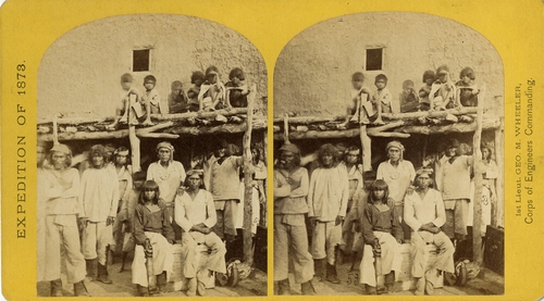
19. Group of Zuni Indian, "Braves," at their Pueblo, N.M.
[Wheeler Survey, Explorations and Surveys West of the 100th Meridian]
1871-1874 (survey), 1873 (expedition)
Stereocard
Etherton Gallery
LL/24746
39 of 101
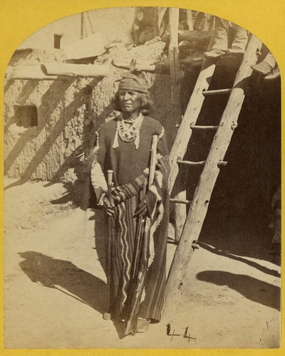
20. War Chief of the Zuni Indians.
[Wheeler Survey, Explorations and Surveys West of the 100th Meridian]
1871-1874 (survey), 1873 (expedition)
Stereocard, detail
Etherton Gallery
LL/24747
40 of 101
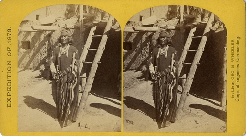
20. War Chief of the Zuni Indians.
[Wheeler Survey, Explorations and Surveys West of the 100th Meridian]
1871-1874 (survey), 1873 (expedition)
Stereocard
Etherton Gallery
LL/24748
41 of 101
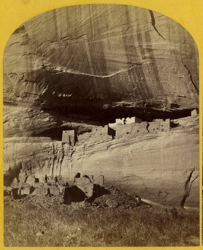
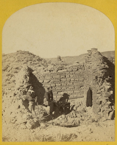
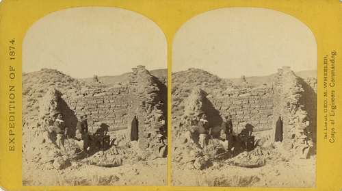
21. Ruins in Canon de Chelle, N.M., in a cavity in the wall, 60 feet above present bed of Canon. Height of walls about 700 feet. The present race of Indians know nothing of the age of these buildings or who occupied them.
[Wheeler Survey, Explorations and Surveys West of the 100th Meridian]
1871-1874 (survey), 1873 (expedition)
Stereocard, detail
Etherton Gallery
LL/24749
42 of 101
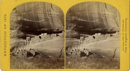
21. Ruins in Canon de Chelle, N.M., in a cavity in the wall, 60 feet above present bed of Canon. Height of walls about 700 feet. The present race of Indians know nothing of the age of these buildings or who occupied them.
[Wheeler Survey, Explorations and Surveys West of the 100th Meridian]
1871-1874 (survey), 1873 (expedition)
Stereocard
Etherton Gallery
LL/24750
43 of 101
22. Circle Wall, Canon de Chelle. Here the Canon bends from an easterly direction, nearly due north, the walls maintaining a perpendicular height of about 1,200 feet.
[Wheeler Survey, Explorations and Surveys West of the 100th Meridian]
1871-1874 (survey), 1873 (expedition)
Stereocard, detail
Etherton Gallery
LL/24751
44 of 101
22. Circle Wall, Canon de Chelle. Here the Canon bends from an easterly direction, nearly due north, the walls maintaining a perpendicular height of about 1,200 feet.
[Wheeler Survey, Explorations and Surveys West of the 100th Meridian]
1871-1874 (survey), 1873 (expedition)
Stereocard
Etherton Gallery
LL/24752
45 of 101
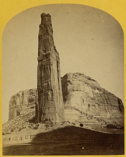
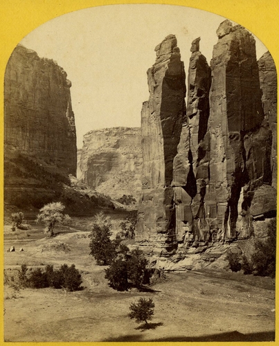
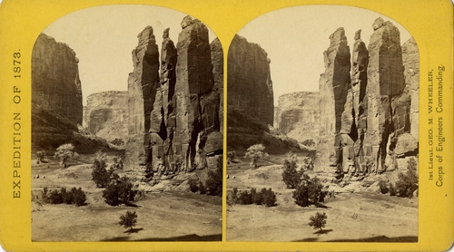
23. Explorers Column, Canon de Chelle, Arizona.
[Wheeler Survey, Explorations and Surveys West of the 100th Meridian]
1871-1874 (survey), 1873 (expedition)
Stereocard, detail
Etherton Gallery
LL/24753
46 of 101
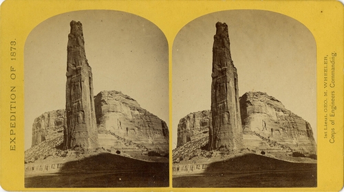
23. Explorers Column, Canon de Chelle, Arizona.
[Wheeler Survey, Explorations and Surveys West of the 100th Meridian]
1871-1874 (survey), 1873 (expedition)
Stereocard
Etherton Gallery
LL/24754
47 of 101
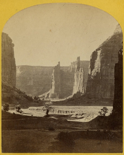
24. Central portion of Canon de Chelle, New Mexico. this Canon is one of the most remarkable in the west, and is noted for its beauty. The walls are of Red Sand-stone, nearly perpendicular, and at this point are 1,200 feet in height.
[Wheeler Survey, Explorations and Surveys West of the 100th Meridian]
1871-1874 (survey), 1873 (expedition)
Stereocard, detail
Etherton Gallery
LL/24755
48 of 101
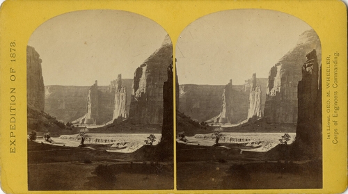
24. Central portion of Canon de Chelle, New Mexico. this Canon is one of the most remarkable in the west, and is noted for its beauty. The walls are of Red Sand-stone, nearly perpendicular, and at this point are 1,200 feet in height.
[Wheeler Survey, Explorations and Surveys West of the 100th Meridian]
1871-1874 (survey), 1873 (expedition)
Stereocard
Etherton Gallery
LL/24756
49 of 101
25. Camp Beauty, Canon de Chelle, walls 1,200 feet high, width of Canon at this point about one fourth of a mile.
[Wheeler Survey, Explorations and Surveys West of the 100th Meridian]
1871-1874 (survey), 1873 (expedition)
Stereocard, detail
Etherton Gallery
LL/24757
50 of 101
25. Camp Beauty, Canon de Chelle, walls 1,200 feet high, width of Canon at this point about one fourth of a mile.
[Wheeler Survey, Explorations and Surveys West of the 100th Meridian]
1871-1874 (survey), 1873 (expedition)
Stereocard
Etherton Gallery
LL/24758
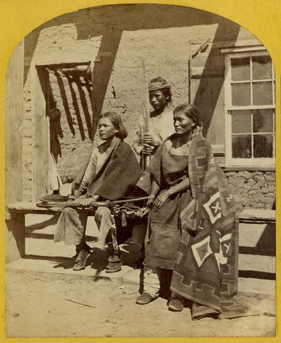
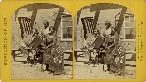
51 of 101
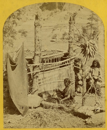
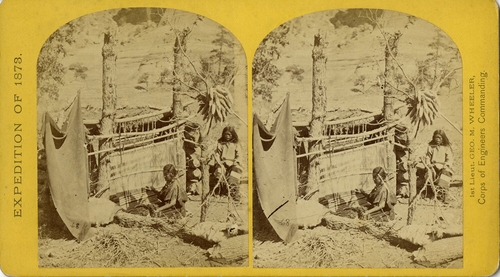
26. Aboriginal life among the Navajo Indians, Canon de Chelle, New Mexico. Squaw weaving blankets. The native loom. The blankets made are of the best quality, and impervious to water.
[Wheeler Survey, Explorations and Surveys West of the 100th Meridian]
1871-1874 (survey), 1873 (expedition)
Stereocard, detail
Etherton Gallery
LL/24759
52 of 101
26. Aboriginal life among the Navajo Indians, Canon de Chelle, New Mexico. Squaw weaving blankets. The native loom. The blankets made are of the best quality, and impervious to water.
[Wheeler Survey, Explorations and Surveys West of the 100th Meridian]
1871-1874 (survey), 1873 (expedition)
Stereocard
Etherton Gallery
LL/24760
53 of 101
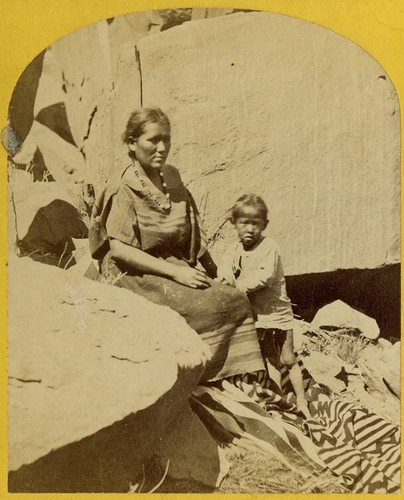
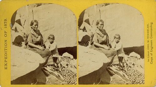
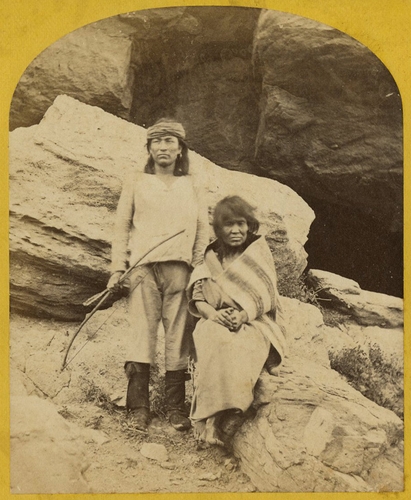
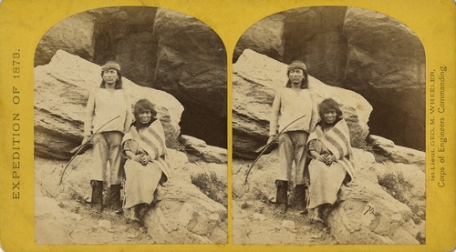
27. Navajo Indian Squaw and Child at their home in Canon de Chelle.
[Wheeler Survey, Explorations and Surveys West of the 100th Meridian]
1871-1874 (survey), 1873 (expedition)
Stereocard, detail
Etherton Gallery
LL/24761
54 of 101
27. Navajo Indian Squaw and Child at their home in Canon de Chelle.
[Wheeler Survey, Explorations and Surveys West of the 100th Meridian]
1871-1874 (survey), 1873 (expedition)
Stereocard
Etherton Gallery
LL/24762
55 of 101
28. Navajo Boys and Squaw, in front of the quarters at old Fort Defiance, N. M., now unoccupied by troops. The agency for the Navajos is located here.
[Wheeler Survey, Explorations and Surveys West of the 100th Meridian]
1871-1874 (survey), 1873 (expedition)
Stereocard, detail
Etherton Gallery
LL/24763
56 of 101
28. Navajo Boys and Squaw, in front of the quarters at old Fort Defiance, N. M., now unoccupied by troops. The agency for the Navajos is located here.
[Wheeler Survey, Explorations and Surveys West of the 100th Meridian]
1871-1874 (survey), 1873 (expedition)
Stereocard
Etherton Gallery
LL/24764
57 of 101
29. Navajo Brave and his Mother. The Navajos were formerly a warlike tribe until subdued by U. S. Troops in 1859-60. Many of them now have fine flocks, and herds of horses, sheep, and goats.
[Wheeler Survey, Explorations and Surveys West of the 100th Meridian]
1871-1874 (survey), 1873 (expedition)
Stereocard, detail
Etherton Gallery
LL/24765
58 of 101
29. Navajo Brave and his Mother. The Navajos were formerly a warlike tribe until subdued by U. S. Troops in 1859-60. Many of them now have fine flocks, and herds of horses, sheep, and goats.
[Wheeler Survey, Explorations and Surveys West of the 100th Meridian]
1871-1874 (survey), 1873 (expedition)
Stereocard
Etherton Gallery
LL/24766
59 of 101
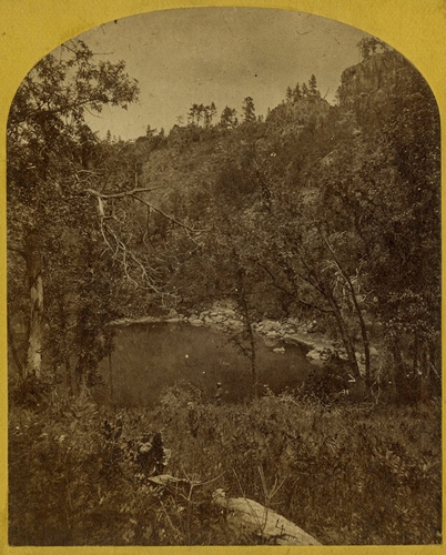
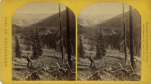
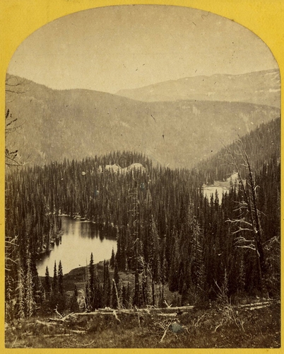
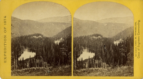
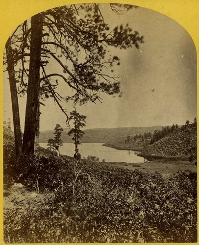
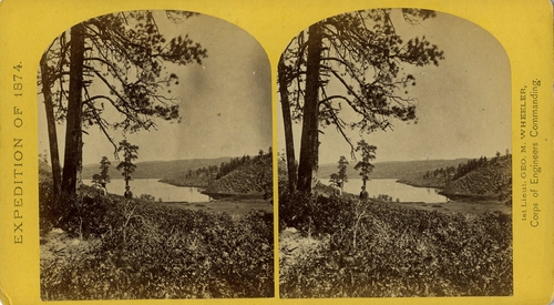
30. Apache Lake, Summit of Sierra Blanca Mountains, about 35 miles east from Camp Apache, Arizona, and 10,500 feet above sea-level. this lake is similar to many found in the western mountains.
[Wheeler Survey, Explorations and Surveys West of the 100th Meridian]
1871-1874 (survey), 1873 (expedition)
Stereocard, detail
Etherton Gallery
LL/24767
60 of 101
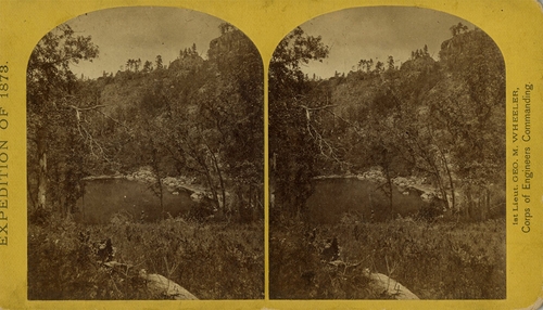
30. Apache Lake, Summit of Sierra Blanca Mountains, about 35 miles east from Camp Apache, Arizona, and 10,500 feet above sea-level. this lake is similar to many found in the western mountains.
[Wheeler Survey, Explorations and Surveys West of the 100th Meridian]
1871-1874 (survey), 1873 (expedition)
Stereocard
Etherton Gallery
LL/24768
61 of 101
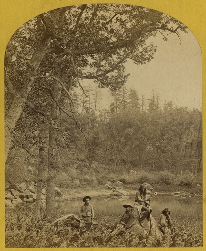
31. Coyotero Apache Scouts, at Apache Lake, Sierra Blanca Mountains, Arizona. Two members of the Expedition in the back-ground.
[Wheeler Survey, Explorations and Surveys West of the 100th Meridian]
1871-1874 (survey), 1873 (expedition)
Stereocard, detail
Etherton Gallery
LL/24769
62 of 101
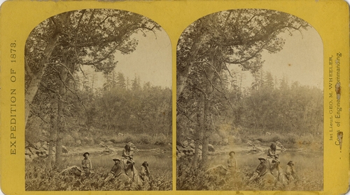
31. Coyotero Apache Scouts, at Apache Lake, Sierra Blanca Mountains, Arizona. Two members of the Expedition in the back-ground.
[Wheeler Survey, Explorations and Surveys West of the 100th Meridian]
1871-1874 (survey), 1873 (expedition)
Stereocard
Etherton Gallery
LL/24770
63 of 101
32. Cooley's Ranch, 10 miles east of Camp Apache, Arizona. A characteristic mountain "Park" and Apache Indian Farm. Here the Apaches grow corn, wheat and a few vegetables.
[Wheeler Survey, Explorations and Surveys West of the 100th Meridian]
1871-1874 (survey), 1873 (expedition)
Stereocard, detail
Etherton Gallery
LL/24771
64 of 101
32. Cooley's Ranch, 10 miles east of Camp Apache, Arizona. A characteristic mountain "Park" and Apache Indian Farm. Here the Apaches grow corn, wheat and a few vegetables.
[Wheeler Survey, Explorations and Surveys West of the 100th Meridian]
1871-1874 (survey), 1873 (expedition)
Stereocard
Etherton Gallery
LL/24772
65 of 101
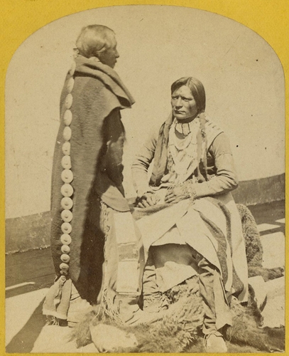
33. Apache Indians, as they appear ready for the war-path.
[Wheeler Survey, Explorations and Surveys West of the 100th Meridian]
1871-1874 (survey), 1873 (expedition)
Stereocard, detail
Etherton Gallery
LL/24773
66 of 101
33. Apache Indians, as they appear ready for the war-path.
[Wheeler Survey, Explorations and Surveys West of the 100th Meridian]
1871-1874 (survey), 1873 (expedition)
Stereocard
Etherton Gallery
LL/24774
67 of 101
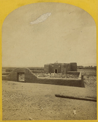
34. Roman Catholic Church, Plaza of Guadaloupe, Guadaloupe Co., Colorado. Built not many years since of adobes. Dimensions, length 120 feet; width 60 feet; height 25 feet. Grave yard in the fore-ground surrounded by an adobe wall about 6 feet in height.
[Wheeler Survey, Explorations and Surveys West of the 100th Meridian]
1871-1874 (survey), 1874 (expedition)
Stereocard, detail
Etherton Gallery
LL/24775
68 of 101
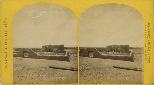
34. Roman Catholic Church, Plaza of Guadaloupe, Guadaloupe Co., Colorado. Built not many years since of adobes. Dimensions, length 120 feet; width 60 feet; height 25 feet. Grave yard in the fore-ground surrounded by an adobe wall about 6 feet in height.
[Wheeler Survey, Explorations and Surveys West of the 100th Meridian]
1871-1874 (survey), 1874 (expedition)
Stereocard
Etherton Gallery
LL/24776
69 of 101

35. Beaver Lake, Conejos Canon, Colorado, 9,000 feet above sea-level, and 30 miles from mouth of Canon.
[Wheeler Survey, Explorations and Surveys West of the 100th Meridian]
1871-1874 (survey), 1874 (expedition)
Stereocard, detail
Etherton Gallery
LL/24777
70 of 101
35. Beaver Lake, Conejos Canon, Colorado, 9,000 feet above sea-level, and 30 miles from mouth of Canon.
[Wheeler Survey, Explorations and Surveys West of the 100th Meridian]
1871-1874 (survey), 1874 (expedition)
Stereocard
Etherton Gallery
LL/24778
71 of 101
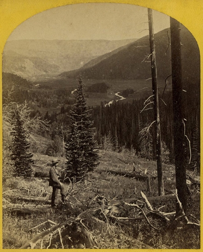
36. Canon, Valley of the Conejos River, looking south from vicinity of "Lost Lakes."
[Wheeler Survey, Explorations and Surveys West of the 100th Meridian]
1871-1874 (survey), 1874 (expedition)
Stereocard, detail
Etherton Gallery
LL/24779
72 of 101
36. Canon, Valley of the Conejos River, looking south from vicinity of "Lost Lakes."
[Wheeler Survey, Explorations and Surveys West of the 100th Meridian]
1871-1874 (survey), 1874 (expedition)
Stereocard
Etherton Gallery
LL/24780
73 of 101
37. Lost Lakes, head of Conejos Canon, Colorado, in the Sierra San Juan range, near divide between Conejos and south fork of Alamosa Rivers, surrounded by a forest of Douglass spruce, and approximately 11,000 feet above sea-level.
[Wheeler Survey, Explorations and Surveys West of the 100th Meridian]
1871-1874 (survey), 1874 (expedition)
Stereocard, detail
Etherton Gallery
LL/24781
74 of 101
37. Lost Lakes, head of Conejos Canon, Colorado, in the Sierra San Juan range, near divide between Conejos and south fork of Alamosa Rivers, surrounded by a forest of Douglass spruce, and approximately 11,000 feet above sea-level.
[Wheeler Survey, Explorations and Surveys West of the 100th Meridian]
1871-1874 (survey), 1874 (expedition)
Stereocard
Etherton Gallery
LL/24782
75 of 101
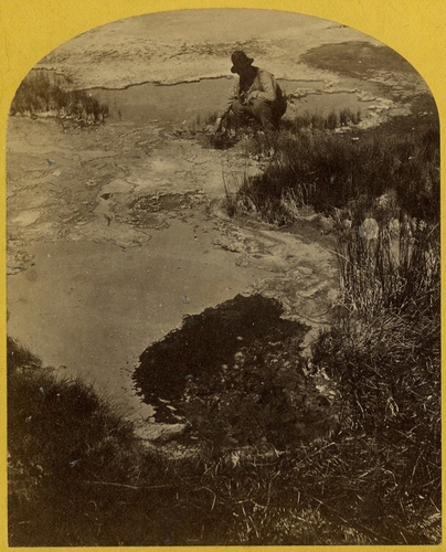
38. One of the group of Pagosa Hot Springs, showing incrustation on the surface. Much prized by the Indians and miners on account of supposed healing qualities. Principal mineral element, Sulphate of Soda.
[Wheeler Survey, Explorations and Surveys West of the 100th Meridian]
1871-1874 (survey), 1874 (expedition)
Stereocard, detail
Etherton Gallery
LL/24783
76 of 101
38. One of the group of Pagosa Hot Springs, showing incrustation on the surface. Much prized by the Indians and miners on account of supposed healing qualities. Principal mineral element, Sulphate of Soda.
[Wheeler Survey, Explorations and Surveys West of the 100th Meridian]
1871-1874 (survey), 1874 (expedition)
Stereocard
Etherton Gallery
LL/24784
77 of 101
39. Pah-ge, a Ute Squaw, of the Kah-poh-teh band, Northern New Mexico.
[Wheeler Survey, Explorations and Surveys West of the 100th Meridian]
1871-1874 (survey), 1874 (expedition)
Stereocard, detail
Etherton Gallery
LL/24785
78 of 101
39. Pah-ge, a Ute Squaw, of the Kah-poh-teh band, Northern New Mexico.
[Wheeler Survey, Explorations and Surveys West of the 100th Meridian]
1871-1874 (survey), 1874 (expedition)
Stereocard
Etherton Gallery
LL/24786
79 of 101
40. Ute Braves, of the Kah-poh-teh band, Northern New Mexico, in "full dress."
[Wheeler Survey, Explorations and Surveys West of the 100th Meridian]
1871-1874 (survey), 1874 (expedition)
Stereocard, detail
Etherton Gallery
LL/24787
80 of 101
40. Ute Braves, of the Kah-poh-teh band, Northern New Mexico, in "full dress."
[Wheeler Survey, Explorations and Surveys West of the 100th Meridian]
1871-1874 (survey), 1874 (expedition)
Stereocard
Etherton Gallery
LL/24788
81 of 101
41. Jicarilla Apache Brave and Squaw, lately wedded. Abiquiu Agency, New Mexico.
[Wheeler Survey, Explorations and Surveys West of the 100th Meridian]
1871-1874 (survey), 1874 (expedition)
Stereocard, detail
Etherton Gallery
LL/24789
82 of 101
41. Jicarilla Apache Brave and Squaw, lately wedded. Abiquiu Agency, New Mexico.
[Wheeler Survey, Explorations and Surveys West of the 100th Meridian]
1871-1874 (survey), 1874 (expedition)
Stereocard
Etherton Gallery
LL/24790
83 of 101
42. Shee-zah-nan-tan, Jicarilla Apache Brave in characteristic costume, Northern New Mexico.
[Wheeler Survey, Explorations and Surveys West of the 100th Meridian]
1871-1874 (survey), 1874 (expedition)
Stereocard, detail
Etherton Gallery
LL/24791
84 of 101
42. Shee-zah-nan-tan, Jicarilla Apache Brave in characteristic costume, Northern New Mexico.
[Wheeler Survey, Explorations and Surveys West of the 100th Meridian]
1871-1874 (survey), 1874 (expedition)
Stereocard
Etherton Gallery
LL/24792
85 of 101
43. Characteristic ruin of the Pueblo San Juan, New Mexico, on the north bank of the San Juan River, about 15 miles west of the mouth of Canon Largo.
[Wheeler Survey, Explorations and Surveys West of the 100th Meridian]
1871-1874 (survey), 1874 (expedition)
Stereocard, detail
Etherton Gallery
LL/24793
86 of 101
43. Characteristic ruin of the Pueblo San Juan, New Mexico, on the north bank of the San Juan River, about 15 miles west of the mouth of Canon Largo.
[Wheeler Survey, Explorations and Surveys West of the 100th Meridian]
1871-1874 (survey), 1874 (expedition)
Stereocard
Etherton Gallery
LL/24794
87 of 101
44. Lagunas Caballo, or Horse Lakes, 14 miles NW from Tierra Amarilla, New Mexico. the water of the lakes is strongly mineral and not fit for men or animals to drink.
[Wheeler Survey, Explorations and Surveys West of the 100th Meridian]
1871-1874 (survey), 1874 (expedition)
Stereocard, detail
Etherton Gallery
LL/24795
88 of 101
44. Lagunas Caballo, or Horse Lakes, 14 miles NW from Tierra Amarilla, New Mexico. the water of the lakes is strongly mineral and not fit for men or animals to drink.
[Wheeler Survey, Explorations and Surveys West of the 100th Meridian]
1871-1874 (survey), 1874 (expedition)
Stereocard
Etherton Gallery
LL/24796
89 of 101
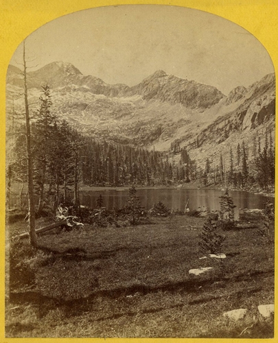
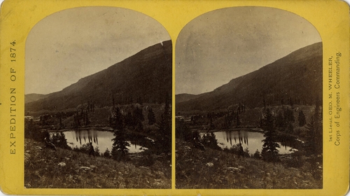
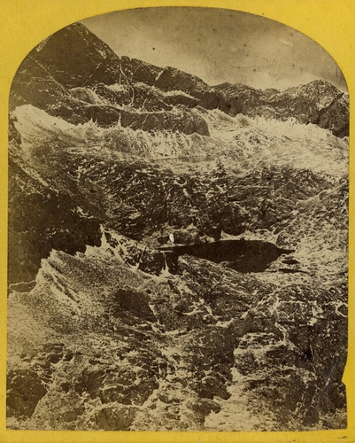
45. Alpine Lake, in the Cerro Blanco Mountains, Colorado. One of a group of ten lakes at the main head of Ute Creek. 11,000 feet above sea-level, Cerro Blanco Peak rises 14,269 feet above the sea, lying to the westward.
[Wheeler Survey, Explorations and Surveys West of the 100th Meridian]
1871-1874 (survey), 1874 (expedition)
Stereocard, detail
Etherton Gallery
LL/24797
90 of 101
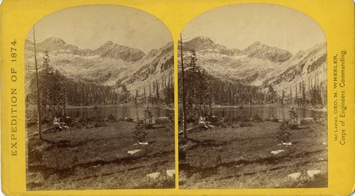
45. Alpine Lake, in the Cerro Blanco Mountains, Colorado. One of a group of ten lakes at the main head of Ute Creek. 11,000 feet above sea-level, Cerro Blanco Peak rises 14,269 feet above the sea, lying to the westward.
[Wheeler Survey, Explorations and Surveys West of the 100th Meridian]
1871-1874 (survey), 1874 (expedition)
Stereocard
Etherton Gallery
LL/24798
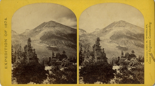
91 of 101
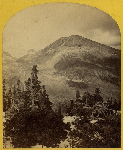
46. Baldy Peak, Cerro Blanco Mountains, Colorado, 14,234 feet above sea-level. Limit in altitude of vegetation about 11,000 feet.
[Wheeler Survey, Explorations and Surveys West of the 100th Meridian]
1871-1874 (survey), 1874 (expedition)
Stereocard, detail
Etherton Gallery
LL/24799
92 of 101
46. Baldy Peak, Cerro Blanco Mountains, Colorado, 14,234 feet above sea-level. Limit in altitude of vegetation about 11,000 feet.
[Wheeler Survey, Explorations and Surveys West of the 100th Meridian]
1871-1874 (survey), 1874 (expedition)
Stereocard
Etherton Gallery
LL/24800
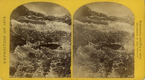
93 of 101
47. Alpine lakes and mountain scenery in the Cerro Blanco Mountains, Colorado, 13,000 feet above sea-level.
[Wheeler Survey, Explorations and Surveys West of the 100th Meridian]
1871-1874 (survey), 1874 (expedition)
Stereocard, detail
Etherton Gallery
LL/24801
94 of 101
47. Alpine lakes and mountain scenery in the Cerro Blanco Mountains, Colorado, 13,000 feet above sea-level.
[Wheeler Survey, Explorations and Surveys West of the 100th Meridian]
1871-1874 (survey), 1874 (expedition)
Stereocard
Etherton Gallery
LL/24802
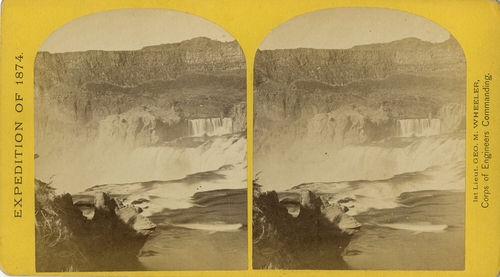
95 of 101
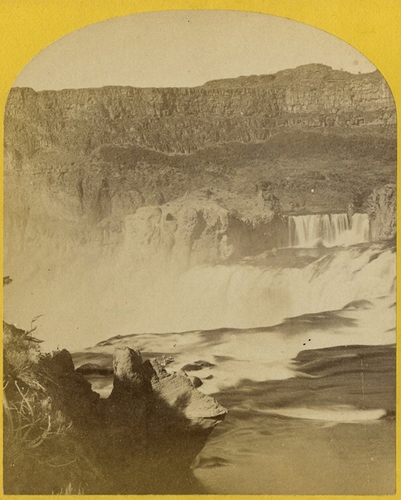
48. Shoshone Falls, Snake River, Idaho, Main Fall, 210 feet from upper to lower level, width of fall 800 feet from upper to lower level; Height of Canon wall at the falls, 1,000 feet.
[Wheeler Survey, Explorations and Surveys West of the 100th Meridian]
1871-1874 (survey), 1874 (expedition)
Stereocard, detail
Etherton Gallery
LL/24803
96 of 101
48. Shoshone Falls, Snake River, Idaho, Main Fall, 210 feet from upper to lower level, width of fall 800 feet from upper to lower level; Height of Canon wall at the falls, 1,000 feet.
[Wheeler Survey, Explorations and Surveys West of the 100th Meridian]
1871-1874 (survey), 1874 (expedition)
Stereocard
Etherton Gallery
LL/24804
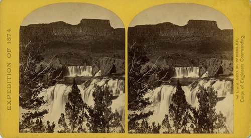
97 of 101
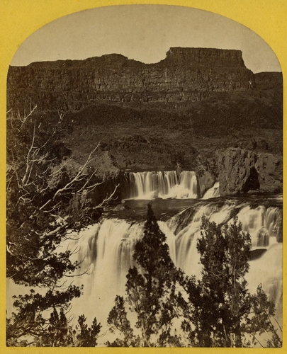
49. Shoshone Falls, Snake River, Idaho, looking through the timber, and showing the main fall, and upper or "Lace Falls."
[Wheeler Survey, Explorations and Surveys West of the 100th Meridian]
1871-1874 (survey), 1874 (expedition)
Stereocard, detail
Etherton Gallery
LL/24805
98 of 101
49. Shoshone Falls, Snake River, Idaho, looking through the timber, and showing the main fall, and upper or "Lace Falls."
[Wheeler Survey, Explorations and Surveys West of the 100th Meridian]
1871-1874 (survey), 1874 (expedition)
Stereocard
Etherton Gallery
LL/24806
99 of 101
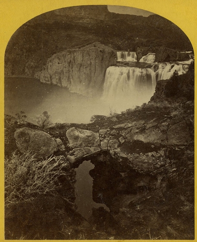
50. Shoshone Falls, Snake River, Idaho. Gorge and natural bridge, in the fore-ground.
[Wheeler Survey, Explorations and Surveys West of the 100th Meridian]
1871-1874 (survey), 1874 (expedition)
Stereocard, detail
Etherton Gallery
LL/24807
100 of 101
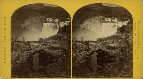
50. Shoshone Falls, Snake River, Idaho. Gorge and natural bridge, in the fore-ground.
[Wheeler Survey, Explorations and Surveys West of the 100th Meridian]
1871-1874 (survey), 1874 (expedition)
Stereocard
Etherton Gallery
LL/24808
101 of 101
101 images
Years
1839 1840 1841 1842 1843 1844 1845 1846 1847 1848 18491850 1851 1852 1853 1854 1855 1856 1857 1858 1859 1860
1861 1862 1863 1864 1865 1866 1867 1868 1869 1870 1871
1872 1873 1874 1875 1876 1877 1878 1879 1880 1881 1882
1883 1884 1885 1886 1887 1888 1889 1890 1891 1892 1893
1894 1895 1896 1897 1898 1899 1900 1901 1902 1903 1904
1905 1906 1907 1908 1909 1910 1911 1912 1913 1914 1915
1916 1917 1918 1919 1920 1921 1922 1923 1924 1925 1926
1927 1928 1929 1930 1931 1932 1933 1934 1935 1936 1937
1938 1939 1940 1941 1942 1943 1944 1945 1946 1947 1948
1949 1950 1951 1952 1953 1954 1955 1956 1957 1958 1959
1960 1961 1962 1963 1964 1965 1966 1967 1968 1969 1970
1971 1972 1973 1974 1975 1976 1977 1978 1979 1980 1981
1982 1983 1984 1985 1986 1987 1988 1989 1990 1991 1992
1993 1994 1995 1996 1997 1998 1999 2000 2001 2002 2003
2004 2005 2006 2007 2008 2009 2010 2011 2012 2013 2014
Contents - Themes & Fragments