 |
Register Subscribe Login |
| 1. |  | Timothy H. O'Sullivan 1871-1874 (survey) Back of stereocard [Wheeler Survey, Explorations and Surveys West of the 100th Meridian] Stereocard Etherton Gallery |
| 2. |  | Timothy H. O'Sullivan 1871-1874 (survey), , 13 September (taken) The start from Camp Mojave, Arizona, September 13, 1871. [Wheeler Survey, Explorations and Surveys West of the 100th Meridian] Stereocard, detail Etherton Gallery 1. The start from Camp Mojave, Arizona, September 13, 1871. Boat expedition under Lieutenant Wheeler, the first and only one to ascend the Colorado through the Grand Ca±on to mouth of Diamond Creek. Distance traveled, 260 miles in 31 days, the boats often having to be portaged around rapids and drawn over rocks. |
| 3. |  | Timothy H. O'Sullivan 1871-1874 (survey), , 13 September (taken) The start from Camp Mojave, Arizona, September 13, 1871. [Wheeler Survey, Explorations and Surveys West of the 100th Meridian] Stereocard Etherton Gallery 1. The start from Camp Mojave, Arizona, September 13, 1871. Boat expedition under Lieutenant Wheeler, the first and only one to ascend the Colorado through the Grand Ca±on to mouth of Diamond Creek. Distance traveled, 260 miles in 31 days, the boats often having to be portaged around rapids and drawn over rocks. |
| 4. |  | Timothy H. O'Sullivan 1871-1874 (survey), (expedition) 2. View across Black Canon. the grand walls in perspective. [Wheeler Survey, Explorations and Surveys West of the 100th Meridian] Stereocard, detail Etherton Gallery |
| 5. |  | Timothy H. O'Sullivan 1871-1874 (survey), (expedition) 2. View across Black Canon. the grand walls in perspective. [Wheeler Survey, Explorations and Surveys West of the 100th Meridian] Stereocard Etherton Gallery |
| 6. |  | Timothy H. O'Sullivan 1871-1874 (survey), (expedition) 3. View down Black Canon, from Mirror Bar. the walls repeated by reflection. [Wheeler Survey, Explorations and Surveys West of the 100th Meridian] Stereocard, detail Etherton Gallery |
| 7. |  | Timothy H. O'Sullivan 1871-1874 (survey), (expedition) 3. View down Black Canon, from Mirror Bar. the walls repeated by reflection. [Wheeler Survey, Explorations and Surveys West of the 100th Meridian] Stereocard Etherton Gallery |
| 8. |  | Timothy H. O'Sullivan 1871-1874 (survey), (expedition) 4. Grotto Spring, Grand Canon, Colorado River. [Wheeler Survey, Explorations and Surveys West of the 100th Meridian] Stereocard, detail Etherton Gallery |
| 9. |  | Timothy H. O'Sullivan 1871-1874 (survey), (expedition) 4. Grotto Spring, Grand Canon, Colorado River. [Wheeler Survey, Explorations and Surveys West of the 100th Meridian] Stereocard Etherton Gallery |
| 10. |  | Timothy H. O'Sullivan 1871-1874 (survey), (expedition) 5. Types of Mojave Indians. this tribe inhabits the region of the lower Colorado, or western Arizona. Physically they are the finest specimens in all the west, many of the males attaining to the height of 8 feet. [Wheeler Survey, Explorations and Surveys West of the 100th Meridian] Stereocard, detail Etherton Gallery |
| 11. |  | Timothy H. O'Sullivan 1871-1874 (survey), (expedition) 5. Types of Mojave Indians. this tribe inhabits the region of the lower Colorado, or western Arizona. Physically they are the finest specimens in all the west, many of the males attaining to the height of 8 feet. [Wheeler Survey, Explorations and Surveys West of the 100th Meridian] Stereocard Etherton Gallery |
| 12. |  | Timothy H. O'Sullivan 1871-1874 (survey), (expedition) 6. View of the Grand Canon walls, near mouth of Diamond River. From waterline to first shelf 1,500 feet; from shelf to top of table 3,500 feet. Distance from point of view to top of walls 3 miles. [Wheeler Survey, Explorations and Surveys West of the 100th Meridian] Stereocard, detail Etherton Gallery |
| 13. |  | Timothy H. O'Sullivan 1871-1874 (survey), (expedition) 6. View of the Grand Canon walls, near mouth of Diamond River. From waterline to first shelf 1,500 feet; from shelf to top of table 3,500 feet. Distance from point of view to top of walls 3 miles. [Wheeler Survey, Explorations and Surveys West of the 100th Meridian] Stereocard Etherton Gallery |
| 14. |  | Timothy H. O'Sullivan 1871-1874 (survey), (expedition) 7. Mountain transportation. Pack mule, Pack and Packers. [Wheeler Survey, Explorations and Surveys West of the 100th Meridian] Stereocard, detail Etherton Gallery |
| 15. |  | Timothy H. O'Sullivan 1871-1874 (survey), (expedition) 7. Mountain transportation. Pack mule, Pack and Packers. [Wheeler Survey, Explorations and Surveys West of the 100th Meridian] Stereocard Etherton Gallery |
| 16. | 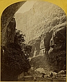 | Timothy H. O'Sullivan 1871-1874 (survey), 1872 (expedition) 8. the Canon of Kanab Creek, near its junction with the Grand Canon of the Colorado. In the foreground is a dripping spring affording a shower bath. Temperature, 69O. Fahr. [Wheeler Survey, Explorations and Surveys West of the 100th Meridian] Stereocard, detail Etherton Gallery |
| 17. |  | Timothy H. O'Sullivan 1871-1874 (survey), 1872 (expedition) 8. the Canon of Kanab Creek, near its junction with the Grand Canon of the Colorado. In the foreground is a dripping spring affording a shower bath. Temperature, 69O. Fahr. [Wheeler Survey, Explorations and Surveys West of the 100th Meridian] Stereocard Etherton Gallery |
| 18. |  | Timothy H. O'Sullivan 1871-1874 (survey), 1872 (expedition) 9. "the Bath," a dripping spring in Kanab Canon. Temperature, 69O. Fahr. [Wheeler Survey, Explorations and Surveys West of the 100th Meridian] Stereocard, detail Etherton Gallery |
| 19. |  | Timothy H. O'Sullivan 1871-1874 (survey), 1872 (expedition) 9. "the Bath," a dripping spring in Kanab Canon. Temperature, 69O. Fahr. [Wheeler Survey, Explorations and Surveys West of the 100th Meridian] Stereocard Etherton Gallery |
| 20. |  | Timothy H. O'Sullivan 1871-1874 (survey), 1872 (expedition) 10. the mouth of Kanab Creek. [Wheeler Survey, Explorations and Surveys West of the 100th Meridian] Stereocard, detail Etherton Gallery |
| 21. |  | Timothy H. O'Sullivan 1871-1874 (survey), 1872 (expedition) 10. the mouth of Kanab Creek. [Wheeler Survey, Explorations and Surveys West of the 100th Meridian] Stereocard Etherton Gallery |
| 22. |  | Timothy H. O'Sullivan 1871-1874 (survey), 1872 (expedition) 11. Mouth of the Paria, Colorado River, walls 2,100 feet in height. [Wheeler Survey, Explorations and Surveys West of the 100th Meridian] Stereocard, detail Etherton Gallery |
| 23. |  | Timothy H. O'Sullivan 1871-1874 (survey), 1872 (expedition) 11. Mouth of the Paria, Colorado River, walls 2,100 feet in height. [Wheeler Survey, Explorations and Surveys West of the 100th Meridian] Stereocard Etherton Gallery |
| 24. |  | Timothy H. O'Sullivan 1871-1874 (survey), 1872 (expedition) 12. View in the Grand Canon of the Colorado River. [Wheeler Survey, Explorations and Surveys West of the 100th Meridian] Stereocard, detail Etherton Gallery |
| 25. |  | Timothy H. O'Sullivan 1871-1874 (survey), 1872 (expedition) 12. View in the Grand Canon of the Colorado River. [Wheeler Survey, Explorations and Surveys West of the 100th Meridian] Stereocard Etherton Gallery |
| 26. |  | Timothy H. O'Sullivan 1871-1874 (survey), 1872 (expedition) 13. Marble Canon, one of the gorges of the Colorado, here 1,200 feet deep. The steep cliff is gray limestone and the slope below a brilliant red sandstone. [Wheeler Survey, Explorations and Surveys West of the 100th Meridian] Stereocard, detail Etherton Gallery |
| 27. |  | Timothy H. O'Sullivan 1871-1874 (survey), 1872 (expedition) 13. Marble Canon, one of the gorges of the Colorado, here 1,200 feet deep. The steep cliff is gray limestone and the slope below a brilliant red sandstone. [Wheeler Survey, Explorations and Surveys West of the 100th Meridian] Stereocard Etherton Gallery |
| 28. | 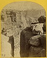 | Timothy H. O'Sullivan 1871-1874 (survey), 1872 (expedition) 14. the northern wall of the Grand Canon of the Colorado, near the foot of To-ro-weap valley. The rounded rocks of the foreground are sand-stone. [Wheeler Survey, Explorations and Surveys West of the 100th Meridian] Stereocard, detail Etherton Gallery |
| 29. |  | Timothy H. O'Sullivan 1871-1874 (survey), 1872 (expedition) 14. the northern wall of the Grand Canon of the Colorado, near the foot of To-ro-weap valley. The rounded rocks of the foreground are sand-stone. [Wheeler Survey, Explorations and Surveys West of the 100th Meridian] Stereocard Etherton Gallery |
| 30. |  | Timothy H. O'Sullivan 1871-1874 (survey), 1872 (expedition) 15. the "Vermillion Cliff," a typical plateau edge, as seen from Jacobs Pool, Arizona. From its top, a plateau stretches to the right, and from its base another to the left. Their difference of level is 1,500 feet, and the step is too steep for scaling. [Wheeler Survey, Explorations and Surveys West of the 100th Meridian] Stereocard, detail Etherton Gallery |
| 31. |  | Timothy H. O'Sullivan 1871-1874 (survey), 1872 (expedition) 15. the "Vermillion Cliff," a typical plateau edge, as seen from Jacobs Pool, Arizona. From its top, a plateau stretches to the right, and from its base another to the left. Their difference of level is 1,500 feet, and the step is too steep for scaling. [Wheeler Survey, Explorations and Surveys West of the 100th Meridian] Stereocard Etherton Gallery |
| 32. | 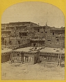 | Timothy H. O'Sullivan 1871-1874 (survey), 1873 (expedition) 16. Indian Pueblo of Zuni, New Mexico; view from the interior. [Wheeler Survey, Explorations and Surveys West of the 100th Meridian] Stereocard, detail Etherton Gallery |
| 33. |  | Timothy H. O'Sullivan 1871-1874 (survey), 1873 (expedition) 16. Indian Pueblo of Zuni, New Mexico; view from the interior. [Wheeler Survey, Explorations and Surveys West of the 100th Meridian] Stereocard Etherton Gallery |
| 34. |  | Timothy H. O'Sullivan 1871-1874 (survey), 1873 (expedition) 17. Zuni Indian girl, with water olla. [Wheeler Survey, Explorations and Surveys West of the 100th Meridian] Stereocard, detail Etherton Gallery |
| 35. |  | Timothy H. O'Sullivan 1871-1874 (survey), 1873 (expedition) 17. Zuni Indian girl, with water olla. [Wheeler Survey, Explorations and Surveys West of the 100th Meridian] Stereocard Etherton Gallery |
| 36. |  | Timothy H. O'Sullivan 1871-1874 (survey), 1873 (expedition) 18. Gardens surrounding the Indian Pueblo of Zuni, in which are raised a variety of vegetables, such as pepper, onions, garlic &c. [Wheeler Survey, Explorations and Surveys West of the 100th Meridian] Stereocard, detail Etherton Gallery |
| 37. |  | Timothy H. O'Sullivan 1871-1874 (survey), 1873 (expedition) 18. Gardens surrounding the Indian Pueblo of Zuni, in which are raised a variety of vegetables, such as pepper, onions, garlic &c. [Wheeler Survey, Explorations and Surveys West of the 100th Meridian] Stereocard Etherton Gallery |
| 38. | 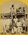 | Timothy H. O'Sullivan 1871-1874 (survey), 1873 (expedition) 19. Group of Zuni Indian, "Braves," at their Pueblo, N.M. [Wheeler Survey, Explorations and Surveys West of the 100th Meridian] Stereocard, detail Etherton Gallery |
| 39. |  | Timothy H. O'Sullivan 1871-1874 (survey), 1873 (expedition) 19. Group of Zuni Indian, "Braves," at their Pueblo, N.M. [Wheeler Survey, Explorations and Surveys West of the 100th Meridian] Stereocard Etherton Gallery |
| 40. |  | Timothy H. O'Sullivan 1871-1874 (survey), 1873 (expedition) 20. War Chief of the Zuni Indians. [Wheeler Survey, Explorations and Surveys West of the 100th Meridian] Stereocard, detail Etherton Gallery |
| 41. |  | Timothy H. O'Sullivan 1871-1874 (survey), 1873 (expedition) 20. War Chief of the Zuni Indians. [Wheeler Survey, Explorations and Surveys West of the 100th Meridian] Stereocard Etherton Gallery |
| 42. |  | Timothy H. O'Sullivan 1871-1874 (survey), 1873 (expedition) 21. Ruins in Canon de Chelle, N.M., in a cavity in the wall, 60 feet above present bed of Canon. Height of walls about 700 feet. The present race of Indians know nothing of the age of these buildings or who occupied them. [Wheeler Survey, Explorations and Surveys West of the 100th Meridian] Stereocard, detail Etherton Gallery |
| 43. |  | Timothy H. O'Sullivan 1871-1874 (survey), 1873 (expedition) 21. Ruins in Canon de Chelle, N.M., in a cavity in the wall, 60 feet above present bed of Canon. Height of walls about 700 feet. The present race of Indians know nothing of the age of these buildings or who occupied them. [Wheeler Survey, Explorations and Surveys West of the 100th Meridian] Stereocard Etherton Gallery |
| 44. |  | Timothy H. O'Sullivan 1871-1874 (survey), 1873 (expedition) 22. Circle Wall, Canon de Chelle. Here the Canon bends from an easterly direction, nearly due north, the walls maintaining a perpendicular height of about 1,200 feet. [Wheeler Survey, Explorations and Surveys West of the 100th Meridian] Stereocard, detail Etherton Gallery |
| 45. |  | Timothy H. O'Sullivan 1871-1874 (survey), 1873 (expedition) 22. Circle Wall, Canon de Chelle. Here the Canon bends from an easterly direction, nearly due north, the walls maintaining a perpendicular height of about 1,200 feet. [Wheeler Survey, Explorations and Surveys West of the 100th Meridian] Stereocard Etherton Gallery |
| 46. |  | Timothy H. O'Sullivan 1871-1874 (survey), 1873 (expedition) 23. Explorers Column, Canon de Chelle, Arizona. [Wheeler Survey, Explorations and Surveys West of the 100th Meridian] Stereocard, detail Etherton Gallery |
| 47. | 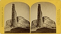 | Timothy H. O'Sullivan 1871-1874 (survey), 1873 (expedition) 23. Explorers Column, Canon de Chelle, Arizona. [Wheeler Survey, Explorations and Surveys West of the 100th Meridian] Stereocard Etherton Gallery |
| 48. |  | Timothy H. O'Sullivan 1871-1874 (survey), 1873 (expedition) 24. Central portion of Canon de Chelle, New Mexico. this Canon is one of the most remarkable in the west, and is noted for its beauty. The walls are of Red Sand-stone, nearly perpendicular, and at this point are 1,200 feet in height. [Wheeler Survey, Explorations and Surveys West of the 100th Meridian] Stereocard, detail Etherton Gallery |
| 49. |  | Timothy H. O'Sullivan 1871-1874 (survey), 1873 (expedition) 24. Central portion of Canon de Chelle, New Mexico. this Canon is one of the most remarkable in the west, and is noted for its beauty. The walls are of Red Sand-stone, nearly perpendicular, and at this point are 1,200 feet in height. [Wheeler Survey, Explorations and Surveys West of the 100th Meridian] Stereocard Etherton Gallery |
| 50. |  | Timothy H. O'Sullivan 1871-1874 (survey), 1873 (expedition) 25. Camp Beauty, Canon de Chelle, walls 1,200 feet high, width of Canon at this point about one fourth of a mile. [Wheeler Survey, Explorations and Surveys West of the 100th Meridian] Stereocard, detail Etherton Gallery |
| 51. |  | Timothy H. O'Sullivan 1871-1874 (survey), 1873 (expedition) 25. Camp Beauty, Canon de Chelle, walls 1,200 feet high, width of Canon at this point about one fourth of a mile. [Wheeler Survey, Explorations and Surveys West of the 100th Meridian] Stereocard Etherton Gallery |
| 52. |  | Timothy H. O'Sullivan 1871-1874 (survey), 1873 (expedition) 26. Aboriginal life among the Navajo Indians, Canon de Chelle, New Mexico. Squaw weaving blankets. The native loom. The blankets made are of the best quality, and impervious to water. [Wheeler Survey, Explorations and Surveys West of the 100th Meridian] Stereocard, detail Etherton Gallery |
| 53. |  | Timothy H. O'Sullivan 1871-1874 (survey), 1873 (expedition) 26. Aboriginal life among the Navajo Indians, Canon de Chelle, New Mexico. Squaw weaving blankets. The native loom. The blankets made are of the best quality, and impervious to water. [Wheeler Survey, Explorations and Surveys West of the 100th Meridian] Stereocard Etherton Gallery |
| 54. |  | Timothy H. O'Sullivan 1871-1874 (survey), 1873 (expedition) 27. Navajo Indian Squaw and Child at their home in Canon de Chelle. [Wheeler Survey, Explorations and Surveys West of the 100th Meridian] Stereocard, detail Etherton Gallery |
| 55. |  | Timothy H. O'Sullivan 1871-1874 (survey), 1873 (expedition) 27. Navajo Indian Squaw and Child at their home in Canon de Chelle. [Wheeler Survey, Explorations and Surveys West of the 100th Meridian] Stereocard Etherton Gallery |
| 56. |  | Timothy H. O'Sullivan 1871-1874 (survey), 1873 (expedition) 28. Navajo Boys and Squaw, in front of the quarters at old Fort Defiance, N. M., now unoccupied by troops. The agency for the Navajos is located here. [Wheeler Survey, Explorations and Surveys West of the 100th Meridian] Stereocard, detail Etherton Gallery |
| 57. |  | Timothy H. O'Sullivan 1871-1874 (survey), 1873 (expedition) 28. Navajo Boys and Squaw, in front of the quarters at old Fort Defiance, N. M., now unoccupied by troops. The agency for the Navajos is located here. [Wheeler Survey, Explorations and Surveys West of the 100th Meridian] Stereocard Etherton Gallery |
| 58. | 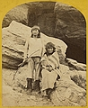 | Timothy H. O'Sullivan 1871-1874 (survey), 1873 (expedition) 29. Navajo Brave and his Mother. The Navajos were formerly a warlike tribe until subdued by U. S. Troops in 1859-60. Many of them now have fine flocks, and herds of horses, sheep, and goats. [Wheeler Survey, Explorations and Surveys West of the 100th Meridian] Stereocard, detail Etherton Gallery |
| 59. |  | Timothy H. O'Sullivan 1871-1874 (survey), 1873 (expedition) 29. Navajo Brave and his Mother. The Navajos were formerly a warlike tribe until subdued by U. S. Troops in 1859-60. Many of them now have fine flocks, and herds of horses, sheep, and goats. [Wheeler Survey, Explorations and Surveys West of the 100th Meridian] Stereocard Etherton Gallery |
| 60. | 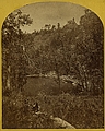 | Timothy H. O'Sullivan 1871-1874 (survey), 1873 (expedition) 30. Apache Lake, Summit of Sierra Blanca Mountains, about 35 miles east from Camp Apache, Arizona, and 10,500 feet above sea-level. this lake is similar to many found in the western mountains. [Wheeler Survey, Explorations and Surveys West of the 100th Meridian] Stereocard, detail Etherton Gallery |
| 61. |  | Timothy H. O'Sullivan 1871-1874 (survey), 1873 (expedition) 30. Apache Lake, Summit of Sierra Blanca Mountains, about 35 miles east from Camp Apache, Arizona, and 10,500 feet above sea-level. this lake is similar to many found in the western mountains. [Wheeler Survey, Explorations and Surveys West of the 100th Meridian] Stereocard Etherton Gallery |
| 62. | 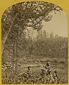 | Timothy H. O'Sullivan 1871-1874 (survey), 1873 (expedition) 31. Coyotero Apache Scouts, at Apache Lake, Sierra Blanca Mountains, Arizona. Two members of the Expedition in the back-ground. [Wheeler Survey, Explorations and Surveys West of the 100th Meridian] Stereocard, detail Etherton Gallery |
| 63. |  | Timothy H. O'Sullivan 1871-1874 (survey), 1873 (expedition) 31. Coyotero Apache Scouts, at Apache Lake, Sierra Blanca Mountains, Arizona. Two members of the Expedition in the back-ground. [Wheeler Survey, Explorations and Surveys West of the 100th Meridian] Stereocard Etherton Gallery |
| 64. |  | Timothy H. O'Sullivan 1871-1874 (survey), 1873 (expedition) 32. Cooley's Ranch, 10 miles east of Camp Apache, Arizona. A characteristic mountain "Park" and Apache Indian Farm. Here the Apaches grow corn, wheat and a few vegetables. [Wheeler Survey, Explorations and Surveys West of the 100th Meridian] Stereocard, detail Etherton Gallery |
| 65. |  | Timothy H. O'Sullivan 1871-1874 (survey), 1873 (expedition) 32. Cooley's Ranch, 10 miles east of Camp Apache, Arizona. A characteristic mountain "Park" and Apache Indian Farm. Here the Apaches grow corn, wheat and a few vegetables. [Wheeler Survey, Explorations and Surveys West of the 100th Meridian] Stereocard Etherton Gallery |
| 66. |  | Timothy H. O'Sullivan 1871-1874 (survey), 1873 (expedition) 33. Apache Indians, as they appear ready for the war-path. [Wheeler Survey, Explorations and Surveys West of the 100th Meridian] Stereocard, detail Etherton Gallery |
| 67. |  | Timothy H. O'Sullivan 1871-1874 (survey), 1873 (expedition) 33. Apache Indians, as they appear ready for the war-path. [Wheeler Survey, Explorations and Surveys West of the 100th Meridian] Stereocard Etherton Gallery |
| 68. |  | Timothy H. O'Sullivan 1871-1874 (survey), 1874 (expedition) 34. Roman Catholic Church, Plaza of Guadaloupe, Guadaloupe Co., Colorado. Built not many years since of adobes. Dimensions, length 120 feet; width 60 feet; height 25 feet. Grave yard in the fore-ground surrounded by an adobe wall about 6 feet in height. [Wheeler Survey, Explorations and Surveys West of the 100th Meridian] Stereocard, detail Etherton Gallery |
| 69. |  | Timothy H. O'Sullivan 1871-1874 (survey), 1874 (expedition) 34. Roman Catholic Church, Plaza of Guadaloupe, Guadaloupe Co., Colorado. Built not many years since of adobes. Dimensions, length 120 feet; width 60 feet; height 25 feet. Grave yard in the fore-ground surrounded by an adobe wall about 6 feet in height. [Wheeler Survey, Explorations and Surveys West of the 100th Meridian] Stereocard Etherton Gallery |
| 70. |  | Timothy H. O'Sullivan 1871-1874 (survey), 1874 (expedition) 35. Beaver Lake, Conejos Canon, Colorado, 9,000 feet above sea-level, and 30 miles from mouth of Canon. [Wheeler Survey, Explorations and Surveys West of the 100th Meridian] Stereocard, detail Etherton Gallery |
| 71. |  | Timothy H. O'Sullivan 1871-1874 (survey), 1874 (expedition) 35. Beaver Lake, Conejos Canon, Colorado, 9,000 feet above sea-level, and 30 miles from mouth of Canon. [Wheeler Survey, Explorations and Surveys West of the 100th Meridian] Stereocard Etherton Gallery |
| 72. |  | Timothy H. O'Sullivan 1871-1874 (survey), 1874 (expedition) 36. Canon, Valley of the Conejos River, looking south from vicinity of "Lost Lakes." [Wheeler Survey, Explorations and Surveys West of the 100th Meridian] Stereocard, detail Etherton Gallery |
| 73. |  | Timothy H. O'Sullivan 1871-1874 (survey), 1874 (expedition) 36. Canon, Valley of the Conejos River, looking south from vicinity of "Lost Lakes." [Wheeler Survey, Explorations and Surveys West of the 100th Meridian] Stereocard Etherton Gallery |
| 74. |  | Timothy H. O'Sullivan 1871-1874 (survey), 1874 (expedition) 37. Lost Lakes, head of Conejos Canon, Colorado, in the Sierra San Juan range, near divide between Conejos and south fork of Alamosa Rivers, surrounded by a forest of Douglass spruce, and approximately 11,000 feet above sea-level. [Wheeler Survey, Explorations and Surveys West of the 100th Meridian] Stereocard, detail Etherton Gallery |
| 75. |  | Timothy H. O'Sullivan 1871-1874 (survey), 1874 (expedition) 37. Lost Lakes, head of Conejos Canon, Colorado, in the Sierra San Juan range, near divide between Conejos and south fork of Alamosa Rivers, surrounded by a forest of Douglass spruce, and approximately 11,000 feet above sea-level. [Wheeler Survey, Explorations and Surveys West of the 100th Meridian] Stereocard Etherton Gallery |
| 76. |  | Timothy H. O'Sullivan 1871-1874 (survey), 1874 (expedition) 38. One of the group of Pagosa Hot Springs, showing incrustation on the surface. Much prized by the Indians and miners on account of supposed healing qualities. Principal mineral element, Sulphate of Soda. [Wheeler Survey, Explorations and Surveys West of the 100th Meridian] Stereocard, detail Etherton Gallery |
| 77. |  | Timothy H. O'Sullivan 1871-1874 (survey), 1874 (expedition) 38. One of the group of Pagosa Hot Springs, showing incrustation on the surface. Much prized by the Indians and miners on account of supposed healing qualities. Principal mineral element, Sulphate of Soda. [Wheeler Survey, Explorations and Surveys West of the 100th Meridian] Stereocard Etherton Gallery |
| 78. |  | Timothy H. O'Sullivan 1871-1874 (survey), 1874 (expedition) 39. Pah-ge, a Ute Squaw, of the Kah-poh-teh band, Northern New Mexico. [Wheeler Survey, Explorations and Surveys West of the 100th Meridian] Stereocard, detail Etherton Gallery |
| 79. |  | Timothy H. O'Sullivan 1871-1874 (survey), 1874 (expedition) 39. Pah-ge, a Ute Squaw, of the Kah-poh-teh band, Northern New Mexico. [Wheeler Survey, Explorations and Surveys West of the 100th Meridian] Stereocard Etherton Gallery |
| 80. |  | Timothy H. O'Sullivan 1871-1874 (survey), 1874 (expedition) 40. Ute Braves, of the Kah-poh-teh band, Northern New Mexico, in "full dress." [Wheeler Survey, Explorations and Surveys West of the 100th Meridian] Stereocard, detail Etherton Gallery |
| 81. |  | Timothy H. O'Sullivan 1871-1874 (survey), 1874 (expedition) 40. Ute Braves, of the Kah-poh-teh band, Northern New Mexico, in "full dress." [Wheeler Survey, Explorations and Surveys West of the 100th Meridian] Stereocard Etherton Gallery |
| 82. |  | Timothy H. O'Sullivan 1871-1874 (survey), 1874 (expedition) 41. Jicarilla Apache Brave and Squaw, lately wedded. Abiquiu Agency, New Mexico. [Wheeler Survey, Explorations and Surveys West of the 100th Meridian] Stereocard, detail Etherton Gallery |
| 83. |  | Timothy H. O'Sullivan 1871-1874 (survey), 1874 (expedition) 41. Jicarilla Apache Brave and Squaw, lately wedded. Abiquiu Agency, New Mexico. [Wheeler Survey, Explorations and Surveys West of the 100th Meridian] Stereocard Etherton Gallery |
| 84. |  | Timothy H. O'Sullivan 1871-1874 (survey), 1874 (expedition) 42. Shee-zah-nan-tan, Jicarilla Apache Brave in characteristic costume, Northern New Mexico. [Wheeler Survey, Explorations and Surveys West of the 100th Meridian] Stereocard, detail Etherton Gallery |
| 85. |  | Timothy H. O'Sullivan 1871-1874 (survey), 1874 (expedition) 42. Shee-zah-nan-tan, Jicarilla Apache Brave in characteristic costume, Northern New Mexico. [Wheeler Survey, Explorations and Surveys West of the 100th Meridian] Stereocard Etherton Gallery |
| 86. |  | Timothy H. O'Sullivan 1871-1874 (survey), 1874 (expedition) 43. Characteristic ruin of the Pueblo San Juan, New Mexico, on the north bank of the San Juan River, about 15 miles west of the mouth of Canon Largo. [Wheeler Survey, Explorations and Surveys West of the 100th Meridian] Stereocard, detail Etherton Gallery |
| 87. |  | Timothy H. O'Sullivan 1871-1874 (survey), 1874 (expedition) 43. Characteristic ruin of the Pueblo San Juan, New Mexico, on the north bank of the San Juan River, about 15 miles west of the mouth of Canon Largo. [Wheeler Survey, Explorations and Surveys West of the 100th Meridian] Stereocard Etherton Gallery |
| 88. |  | Timothy H. O'Sullivan 1871-1874 (survey), 1874 (expedition) 44. Lagunas Caballo, or Horse Lakes, 14 miles NW from Tierra Amarilla, New Mexico. the water of the lakes is strongly mineral and not fit for men or animals to drink. [Wheeler Survey, Explorations and Surveys West of the 100th Meridian] Stereocard, detail Etherton Gallery |
| 89. |  | Timothy H. O'Sullivan 1871-1874 (survey), 1874 (expedition) 44. Lagunas Caballo, or Horse Lakes, 14 miles NW from Tierra Amarilla, New Mexico. the water of the lakes is strongly mineral and not fit for men or animals to drink. [Wheeler Survey, Explorations and Surveys West of the 100th Meridian] Stereocard Etherton Gallery |
| 90. |  | Timothy H. O'Sullivan 1871-1874 (survey), 1874 (expedition) 45. Alpine Lake, in the Cerro Blanco Mountains, Colorado. One of a group of ten lakes at the main head of Ute Creek. 11,000 feet above sea-level, Cerro Blanco Peak rises 14,269 feet above the sea, lying to the westward. [Wheeler Survey, Explorations and Surveys West of the 100th Meridian] Stereocard, detail Etherton Gallery |
| 91. |  | Timothy H. O'Sullivan 1871-1874 (survey), 1874 (expedition) 45. Alpine Lake, in the Cerro Blanco Mountains, Colorado. One of a group of ten lakes at the main head of Ute Creek. 11,000 feet above sea-level, Cerro Blanco Peak rises 14,269 feet above the sea, lying to the westward. [Wheeler Survey, Explorations and Surveys West of the 100th Meridian] Stereocard Etherton Gallery |
| 92. |  | Timothy H. O'Sullivan 1871-1874 (survey), 1874 (expedition) 46. Baldy Peak, Cerro Blanco Mountains, Colorado, 14,234 feet above sea-level. Limit in altitude of vegetation about 11,000 feet. [Wheeler Survey, Explorations and Surveys West of the 100th Meridian] Stereocard, detail Etherton Gallery |
| 93. |  | Timothy H. O'Sullivan 1871-1874 (survey), 1874 (expedition) 46. Baldy Peak, Cerro Blanco Mountains, Colorado, 14,234 feet above sea-level. Limit in altitude of vegetation about 11,000 feet. [Wheeler Survey, Explorations and Surveys West of the 100th Meridian] Stereocard Etherton Gallery |
| 94. | 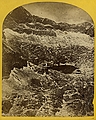 | Timothy H. O'Sullivan 1871-1874 (survey), 1874 (expedition) 47. Alpine lakes and mountain scenery in the Cerro Blanco Mountains, Colorado, 13,000 feet above sea-level. [Wheeler Survey, Explorations and Surveys West of the 100th Meridian] Stereocard, detail Etherton Gallery |
| 95. |  | Timothy H. O'Sullivan 1871-1874 (survey), 1874 (expedition) 47. Alpine lakes and mountain scenery in the Cerro Blanco Mountains, Colorado, 13,000 feet above sea-level. [Wheeler Survey, Explorations and Surveys West of the 100th Meridian] Stereocard Etherton Gallery |
| 96. |  | Timothy H. O'Sullivan 1871-1874 (survey), 1874 (expedition) 48. Shoshone Falls, Snake River, Idaho, Main Fall, 210 feet from upper to lower level, width of fall 800 feet from upper to lower level; Height of Canon wall at the falls, 1,000 feet. [Wheeler Survey, Explorations and Surveys West of the 100th Meridian] Stereocard, detail Etherton Gallery |
| 97. |  | Timothy H. O'Sullivan 1871-1874 (survey), 1874 (expedition) 48. Shoshone Falls, Snake River, Idaho, Main Fall, 210 feet from upper to lower level, width of fall 800 feet from upper to lower level; Height of Canon wall at the falls, 1,000 feet. [Wheeler Survey, Explorations and Surveys West of the 100th Meridian] Stereocard Etherton Gallery |
| 98. |  | Timothy H. O'Sullivan 1871-1874 (survey), 1874 (expedition) 49. Shoshone Falls, Snake River, Idaho, looking through the timber, and showing the main fall, and upper or "Lace Falls." [Wheeler Survey, Explorations and Surveys West of the 100th Meridian] Stereocard, detail Etherton Gallery |
| 99. | 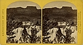 | Timothy H. O'Sullivan 1871-1874 (survey), 1874 (expedition) 49. Shoshone Falls, Snake River, Idaho, looking through the timber, and showing the main fall, and upper or "Lace Falls." [Wheeler Survey, Explorations and Surveys West of the 100th Meridian] Stereocard Etherton Gallery |
| 100. |  | Timothy H. O'Sullivan 1871-1874 (survey), 1874 (expedition) 50. Shoshone Falls, Snake River, Idaho. Gorge and natural bridge, in the fore-ground. [Wheeler Survey, Explorations and Surveys West of the 100th Meridian] Stereocard, detail Etherton Gallery |
| 101. |  | Timothy H. O'Sullivan 1871-1874 (survey), 1874 (expedition) 50. Shoshone Falls, Snake River, Idaho. Gorge and natural bridge, in the fore-ground. [Wheeler Survey, Explorations and Surveys West of the 100th Meridian] Stereocard Etherton Gallery |